
St. Louis Riverfront Trail
A Confluence Attraction
Contact
Doug Eller, Grace Hill Settlement House
(314) 584-6703
Participating Confluence Organizations
Grace Hill Settlement House
Great Rivers Greenway District
City of St. Louis MO
Trailnet
Location
Spans 11 miles along the Mississippi River from the Laclede Power Building (one mile north of the Gateway Arch) to the Old Chain of Rocks Bridge on Riverview Drive. The main trailhead with parking lot is located at the intersection of Lewis and Biddle Streets just north of the President casino.
Directions
(By car to Biddle trailhead) From downtown St. Louis, take Washington Avenue east, past the Gateway Arch grounds to the riverfront. Turn left on Leonor K. Sullivan Boulevard. Proceed north a short distance, past the President Casino. Parking is available in the lot at the intersection of Lewis and Biddle Streets.
(By bike) The Riverfront Trail can be reached from the MCT Confluence Trail in Illinois via the Old Chain of Rocks Bridge.
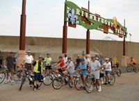
Frequent Riverfront Trail Riders
If you have been wondering about the foldable bollards on the Trail and when they will be going up to keep illegal vehicular traffic out, please note that bollards will be folded upright beginning Wednesday, May 14, 2008. AmeriCorps Trail Rangers have taken on the task to keep them vertical. If you notice irregularities, and Rangers do expect problems, drop a comment or note at the Mary Meachum Visitor Center. Safe cycling!
Trail Map
Download pdf (636 KB)
View Video of Riverfront Trail Ride
Current Features
| Current Features | |
|
In 2007, Riverfront Trail enhancements including re-paving, new signage, parking, rest areas and drinking fountains were completed by the Great Rivers Greenway District and the City of St. Louis. |
 |
|
The Trail travels along the St. Louis floodwall, much of the time bordering the Mississippi River. The downtown section of the floodwall is marked by a 190-foot ceramic mural, Reflecting on a River, depicting the flora and fauna of the Mississippi River. Created by ceramic artist Catharine Magel, many of the creatures were crafted by community residents and school students. Download a PowerPoint presentation by artist Catharine Magel on this public art project (8.2 M). Funding provided by:
|
 |
|
Roughly the first one-half of the trail travels through the “working riverfront” of industrial and shipping facilities. The remainder contains more open vistas of a natural stretch of river opposite Chouteau Island along the Illinois shore. Native plants and animals can be found along the entire length of the trail, which currently terminates at the Old Chain of Rocks Bridge, connecting to Illinois and the MCT Confluence Trail. View the KETC Living St. Louis segment on the Riverfront Trail Reqires Apple QuickTime Player or Windows Media Player to view video |
 |
|
Boeing Creates Trail of Discovery |
 |
|
Three miles north of downtown St. Louis, next to the old Merchant’s Bridge, is the Mary Meachum Freedom Crossing, Missouri’s first nationally recognized Underground Railroad site (described elsewhere on this website). Also at this location is a rest stop and native plant nursery housed in a former Coast Guard boat facility. It is staffed during peak periods by the Grace Hill AmeriCorps Trail Rangers, who provide directions, general and mechanical assistance. |
 |
|
North Riverfront Park, located nine miles north of downtown, offers excellent spots for picnicking and fishing, including a boat launch. |
 |
|
The St. Louis Riverfront Trail overlaps with a portion of the cross-country Mississippi River Trail. |
 |
| Future Plans | |
|
Trailnet is spearheading renovation of the Laclede Power Center, a former power plant constructed prior to the 1904 World’s Fair, to serve as The Confluence project’s downtown visitor center. View the KETC Living St. Louis segment "Warehouse Photography," which shows some wonderful views from inside the Laclede Power Building Reqires Apple QuickTime Player or Windows Media Player to view video |
 |
|
The Great Rivers Greenway District is developing the Iron Horse Trestle into an elevated bikeway. The renovated trestle will be only the third of its kind in the world and the only development accommodating bicycles. The bikeway offers fabulous vistas of the Mississippi River and downtown skyline, creative features involving elevated landscaping, art, event venues, and environmentally sustainable amenities. It is a vital pedestrian/biking transportation link between Missouri and Illinois. The former railroad trestle extends two miles from Cass Street on the south, over Highway 70, to Branch Street on the north. View the KETC Living St. Louis segment on renovation of McKinley Bridge Reqires Apple QuickTime Player or Windows Media Player to view video |
 |
Mississippi River Trail
The following ride is accessible from the MRT and would make a good day trip for those on a longer MRT excursion. This ride takes in Confluence sites including the Riverfront Trail, Old Chain of Rocks Bridge, Chouteau Island, Lewis & Clark State Historic Site, Great Rivers Museum, and Vadalabene Trail and Pere Marquette State Park on the longer route.
St. Louis, MO – Alton, IL – 25.7 miles
Starting at the Gateway Arch (literally the street below the Arch along the riverfront) cyclists can go north on Leonor K. Sullivan Blvd. to the trailhead for the St. Louis Riverfront Trail. This 11-mile paved trail offers panoramic views of the Mississippi River, bisects the working riverfront, and skirts old St. Louis neighborhoods before opening to prairie vistas. The Mary Meachum Rest Area is open limited hours and has restroom facilities, shade, and if the Grace Hill AmeriCorps Trail Rangers are there they can provide interpretation on this Underground Railroad site. The Old Chain of Rocks Bridge (11 miles from the Arch), a former Route 66 crossing provides panoramic views of the natural river with the St. Louis skyline in the distance. Restrooms, shade and picnic tables make this a good place to stop and enjoy the view. (Note: bring water and food with you as there are no facilities to purchase supplies along the trail for a 25.7 mile stretch.)
After crossing the Bridge you will be on Chouteau Island, its claim to fame is Lewis & Clark camped here. Cross over the canal bridge and make an immediate left to connect to the MCT Confluence Trail which goes to Alton, IL. (Continue straight on this road, less than 1 mile you will hit IL Route 3. There is a convenience store and fast food at this intersection.) Continuing on the Confluence Trail going north you are traveling along the levee, watch the barges float by as you make your way to the Lewis & Clark State Historic Site at Hartford, IL. A spur trail will take you to the door of the Museum and Visitor’s Center, definitely worth spending some time to see the film on the famous explorers and checking out the exhibits (during operating hours you can access the restroom facilities). Scheduled for opening in September 2006 is the Hartford Tower that will give visitors an aerial view of the meeting of the Great Rivers, the Missouri and Mississippi). You cannot miss the Tower as the trail goes right by it.
Back on the trail your next stop should be the Great Rivers Museum at the Melvin Price Locks & Dam near Alton, IL (17.3 miles from the Arch). Again a trail spur leads to the Museum. This US Army Corps of Engineers regional visitors center features interactive exhibits that explores our natural and cultural connections to the river. The large bridge upriver is the Clark Bridge in Alton. The trail ends at Russell Commons Park where there are restroom facilities, water and picnic shelters (25.7 miles from the Arch). If you are in search of food Alton offers lots of options to please the palate. Some might say Fast Eddies, catering to the motorized bicyclists (hamburgers, shrimp skewers and beer) is a must see while others may prefer the soup, salad, sandwich menu at My Just Desserts (also know for their pie!). The Alton Visitor’s Center at 200 Piasa can provide you with destinations and directions.
Still wanting to do some more pedaling (?) or to extend your trip a day follow the Vadalabene Trail out of Alton along the Great River Road. The views of the bluffs are spectacular any time of year but especially colorful in the fall. Take a minute to view the Piasa Bird carved into the limestone bluff and read about its history. The river communities along the trail all have their own unique offerings (wineries, Bed & Breakfasts, antiques, seasonal produce stands, panoramic views as you ascend the bluffs and look down). The trail ends at Pere Marquette State Park (22 miles from Alton to the Park), the lodge serves food and provides overnight accommodations.
Old North St. Louis History Trail
The layers of history unfold on the streets of Old North St. Louis. Located just three miles north of the Gateway Arch and a short distance from the Mississippi River, Old North St. Louis is among the oldest and most culturally diverse neighborhoods in the city. Historic homes, churches, shops and parks reveal its transformation from river town to crowded immigrant quarter to urban renewal district. The History Trail is easily accessed from the Riverfront Trail using Branch Street. To print or view a PDF format brochure including 30 features along the Old North St. Louis History Trail, click here (6.3 mb).
Riverfront Trail Creative Interpretation
Grace Hill Settlement unveil a short-term navigation and interpretation project by St. Louis poet, Jane Ellen Ibur and Cobden, Illinois artist Mel Watkin in November, 2005. The project was funded through grants from the St. Louis Regional Arts Commission and the Great Rivers Greenway with support from the Missouri Department of Natural Resources, Americorps Trail Rangers and Trailnet.
Ibur and Watkin collaborated to come up with the concept for the project and worked with Doug Eller of Grace Hill and the Trail Rangers to decide which topics to write about. The poems have been stenciled onto the flood wall and directly on the Trail at Merchant's Bridge, McKinley Bridge, Mosenthein Island and Maline Creek. The native trumpet vine leads up to and surrounds the poetry.
|
Song of the Mississippi Jane Ellen Ibur |
Song of the Girders Jane Ellen Ibur |
|
Song of the Islands Jane Ellen Ibur
|
Song of the Girders |

The poems are written to spark curiosity about the rich industrial and natural history of the Riverfront Trail. To download some historical sources provided by the Missouri Department of Natural Resources' State Historic Preservation Office used as resource material for this project (click here, 40KB).
Future Plans
Preliminary improvements and renovations to the Laclede Power Building will permit it to deliver basic rest services in 2006.
The Mary Meachum Freedom Crossing will be developed as a tourism venue, reflecting extensive community participation in its design.
A former pier at the site of the Meachum rest building will be reconstructed for fishing and closer access to the river.
The Trail will receive extensive native plant landscaping over time, supported by a plant nursery established at the Meachum rest stop.
Connectors will be constructed from the Trail into historic North St. Louis neighborhoods to its west, which will facilitate economic revitalization and permit exploration of some of the city’s oldest residential communities.
For more information about the St. Louis Riverfront Trail, see
http://www.trailnet.org
For more information about nearby trails, see
http://www.stlbiking.com/Trail-STLriverFront.htm
http://www.mississippirivertrail.org
For more information about AmeriCorps National Service Programs, see
http://www.americorps.org


